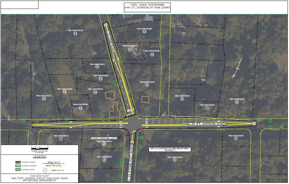
SC DOT performed a traffic study to determine if the intersection warranted traffic signals. The study determined that the intersection does not meet the requirements for a traffic signal. The study also stated that if traffic volumes in the future reach a level where signalization could be justified, that at a minimum, left-turn lanes on Fort Johnson Road would be required. In November of 2016, Charleston County citizens voted for the 2016 Transportation Sales Tax referendum.
The County identified and dedicated funding from the 2016 Transportation Sales Tax for the Fort Johnson and Camp Road Intersection Improvement project. County Staff met with various stakeholders to discuss transportation projects on James Island, this included elected officials, SCDOT, the Town of James Island, the City of Charleston, and citizens. Near the end of the year, the County contracted with an engineering consulting firm for the design.
The County performed a roadside safety audit in early 2018 to verify safety issues and to identify short term improvements at the intersection. The identified improvements were implemented by the County, SCDOT, and the Town of James Island. A cultural study on the stone monuments and a right of way study were also completed.
The County developed 30% preliminary design plans and utility coordination began.
The County presented the preferred alternative design to improve safety at the intersection. Preliminary design plan development and utility coordination continued.
The County completed 65% preliminary plan development, completed the environmental site assessment, and continued utility coordination.
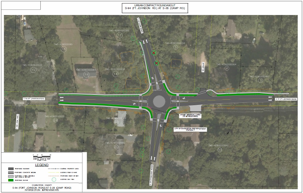
The County gained concurrence from SCDOT on the design plans for the urban compact roundabout alternative to minimize impacts on grand trees and right-of-way, developed Right of Way plans and submitted to SCDOT for approval, developed relocation options for the stone monuments, submitted an application to the Town of James Island Board of Zoning Appeals to remove two grand live oak trees, and continued utility coordination.
Board of Zoning Appeals approved the removal of two grand live oak trees needed to construct the preferred alternative, (the urban compact roundabout). SCDOT approved the project right-of-way plans, right-of-way acquisition is well underway, an agreement between the Town, City, and County was made concerning a plan for the easements for the stone monuments, and draft utility relocation plans for water and sewer have been developed.
The project team analyzed four alternatives (including a no-build option) for the intersection at Fort Johnson Road and Camp Road.
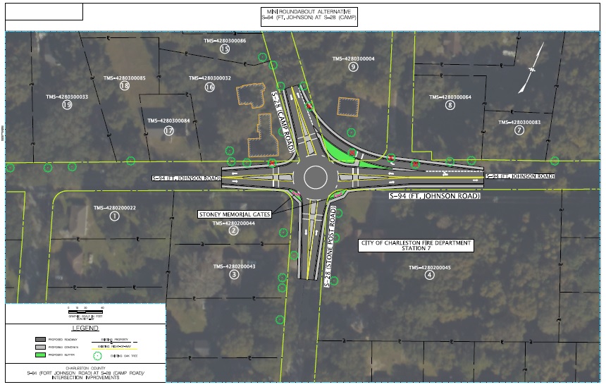
To determine which alternative best met the project goals, the project team evaluated right of way (ROW) impacts, grand tree impacts, property relocations, construction costs, and the projected traffic impacts. Staff recommends Alternative 1, an Urban Compact Roundabout for the intersection at Fort Johnson Road and Camp Road. Below you will find the recommended alternative and the additional alternatives the County considered.

| Category | Impact |
|---|---|
| ROW (acres) | 0.3 |
| Grand Oak Tree(s) Removal | 2 |
| Level of Service* AM/PM (up to year 2037) | D/E |
| Property Relocations | 0 |
| Construction Cost ($ Million) | $1.4 |

| Category | Impact |
|---|---|
| ROW (acres) | 0.4 |
| Grand Oak Tree(s) Removal | 5 |
| Level of Service* AM/PM (up to year 2037) | C/D |
| Property Relocations | 0 |
| Construction Cost ($ Million) | $1.5 |

| Category | Impact |
|---|---|
| ROW (acres) | 0.5 |
| Grand Oak Tree(s) Removal | 16 |
| Level of Service* AM/PM (up to year 2037) | F/F |
| Property Relocations | 0 |
| Construction Cost ($ Million) | $1.6 |
*Level of service (LOS) is a scale that rates how well a transportation facility is operating from a traveler's perspective. Typically, the six levels of service are rated from A to F, with LOS A representing the best operating conditions, and LOS F the worst. Project managers use LOS to describe how a roadway or intersection is currently functioning, or how they will function in the future with or without improvements.
Why was a traffic signal alternative not presented?
The amount of traffic at this intersection does not meet the SCDOT's requirements to consider the installation of a traffic signal. The volume of traffic must meet SCDOT criteria for the County to consider a traffic signal alternative.
Why are you recommending an alternative that does not provide the best level of service?
While Alternative 2 does operate slightly better in terms of traffic flow, it would
require the removal of 3 additional grand live oak trees. The County is committed
to preserving as many grand live oak trees as possible while still meeting the
purpose of the project. Alternative 1, the recommended alternative will still improve
safety and traffic flow compared to if the County did no improvements.
What is the difference between Alternative 1 and Alternative 2?
Alternative 1 is referred to as an urban compact roundabout (UCR), and Alternative
2 is a considered a mini-roundabout. A UCR is smaller than a mini-roundabout and
considered more pedestrian and bicycle friendly. This is because vehicles entering
the UCR must do so at very low speeds, providing pedestrian and bicyclists a safe
and effective use of the intersection. The smaller size of the UCR will improve
safety at the intersection without additional impacts to grand live oak trees.
Will Alternative 1, the urban compact roundabout, accommodate
trucks, trailers, and recreational vehicles?
The center of UCR in Alternative 1 will consist of a raised median with a rolling curb.
This will allow trucks, trailers, and recreational vehicles to travel the UCR with ease.
Will the center of Alternative 1, the urban compact roundabout, be landscaped?
No. In order to ensure that larger vehicles can safely navigate the small size of the UCR, Alternative 1 will not include landscaping.
What’s going to happen with the stone posts at Camp Road?
The County intends to relocate the stone posts within the new right of way.
Why are the stone posts at Camp Road important to the community?
The stone gates were erected in 1926 at the entrance to the Agricultural Society of South Carolina (AGSC) tract on James Island. They serve to memorialize the early agricultural research center and the AGSC’s former president, Arnold G. Stoney. Although a 1998 auto accident damaged the east post, the damaged portions were repaired.
Are the stone posts at Camp Road historic?
The State Historic Preservation Office (SHPO) has concurred with a preliminary study that indicates the posts are not eligible for listing on the National Register of Historic Places.
If you are considering all modes of transportation, why are there not sidewalks through the entire construction limits?
We will keep existing sidewalks in place and add proposed sidewalks where there is not property owner opposition.
Are we getting street lighting for Fort Johnson and Camp Road?
The County is considering proposed lighting for the Fort Johnson Road and Camp Road roundabout. We welcome your input regarding the inclusion of lighting in the Camp Road roundabout project.
I don’t understand why we can’t simply put up stop signs and make an all way stop?
In order to utilize an All Way Stop Control (AWSC) for this intersection, it must meet SCDOT criteria. The primary criteria for an all-way stop is that the major and minor streets have approximately equal volume. Based on the 2016 traffic count, traffic on Fort Johnson Road is significantly higher than the traffic on Camp Road and Stone Post Road. In addition, the level of service with AWSC, even with turn lanes, is not acceptable and would create excessive delays. This delay exceeds what SCDOT standards allow.
What type of trees are being impacted?
The intersection improvement project will impact two grand live oak trees (44” and 36”), both are in poor condition based on the results of a December 2022 assessment performed by a Certified Master Arborist.

